
 It is not clear how the name Assam came into existence. The name "Assam" may be derived from the Sanskrit term "Asom" that means unparalleled, or one with no equal. The term "Asom" in Sanskrit also means undulated or uneven. The rugged nature of the land of Assam may also be a reason for her name. In addition, the Ahoms ruled Assam for six hundred years till the early part of the 19th century. The words "Ahom" and "Asom" are pronounced similarly, and hence the Ahoms may also have given Assam its names.
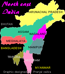
During the British Raj, till 1947, Assam comprised most of Northeast India, except the tiny erstwhile kingdom of Tripura to the south, and the British-administered territory of Manipur to the east. However, modern Assam is a diminutive form of its old self. The government of India, which has the unilateral powers to change the borders of a state, divided Assam into several states in the 1970s to satisfy national aspirations of the tribal populations living within the then borders of then Assam, and for other political reasons. Whereas at one time Assam had extensive international borders with China/Tibet and Burma, modern Assam's international borders are limited to those with the small country of Bhutan in the northwest and with Bangladesh to the southwest. Assam is bordered on the north by the Indian state of Arunachal Pradesh that used to be an administrative part of Assam till the 1970s. To the east of Assam are the Indian states of Arunachal Pradesh, Nagaland, and Manipur; to the south are the Indian states of Mizoram and Meghalaya; and to the west are Bangladesh and the Indian state of Tripura. Except for a narrow corridor running through the foothills of the Himalayas that connects the state with West Bengal, Assam is almost entirely isolated from India. The capital of Assam used to be Shillong in the modern state of Meghalaya for more than a hundred years till it was moved to Dispur, a suburb of Guwahati in 1972, after Meghalaya became a separate state of India.
Assam comprises an area of 78,523 square kilometers (30,318 square miles). Modern Assam has 22 districts which are akin to counties in the US or the UK. Except for the districts of Karbi Anglong and North Cachar Hills, Assam is generally composed of plains and river valleys. It can be divided into three principal geographical regions: the Brahmaputra Valley in the north; the Barak Plain in the south; and the Mikir (Karbi Anglong) and Cachar Hills that divide the two regions.
The northern part of Assam is wholly occupied by the elongated valley of the mighty river Brahmaputra. Most of Assam's population lives in this valley. The Brahmaputra valley is bounded by the foothills of the Himalayas to the north and another lower range of hills and mountains to the south. In the center part of Assam, to the south of the hills is the Barak Valley which is contiguous with the densely populated country of Bangladesh.
The Brahmaputra Valley is the dominant physical feature of Assam. The Brahmaputra enters Assam near Sadiya at the extreme northeast corner and runs westward for nearly 450 miles before turning south to enter the plains of Bangladesh. The river valley, rarely more than 50 miles wide, is studded with numerous low, isolated hills and ridges that abruptly rise from the plain. The valley, surrounded on all sides, except the west, by mountains and is intersected by many streams and rivulets that flow from the neighboring hills to empty into the Brahmaputra.
Earthquakes are a common phenomenon in Assam. In modern times, the most important Assamese earthquakes have been those that occurred in 1897 with the Shillong Plateau as the epicenter; in 1930 with Dhubri as the epicenter; and 1950, with Rima in Tibet at the Arunachal border as the epicenter. The 1950 earthquake is considered to have been one of the most disastrous earthquakes in history. It created heavy landslides that blocked the course of many hill streams.
The average temperature is moderate, about 84 degrees F (29 degress C) in the hottest month of August. The average valley temperature in January is 61 degrees F (16 degrees C). In this season, the climate of the valley is marked by heavy fogs and a little rain. Assam does not have the normal Indian hot, dry season. Some rain occurs from March onwards, but the real force of the monsoon winds is faced from June onward. Rainfall in Assam ranks among the highest in the world; its annual rainfall varies from 70 inches in the west to 120 inches per year in the east. Large concentrated during the months from June to September, it often results in widespread destructive floods.
Assam's forests cover about 20 percent of the total area. The Kaziranga National Park, the stronghold of the fast-disappearing great Indian one-horned rhinoceros, is its most famous wildlife refuge. The most important forest products are timber and bamboo, firewood and lac (the source of shellac). There are about 74 species of timber, of which two-thirds are commercially exploited. The forests are inhabited by wild animals such as elephants, tigers, deer and wild pigs.